![Looking west from Bonpo Bridge in South Gyeongsang on Oct. 2. [JIM BULLEY]](https://imgnews.pstatic.net/image/640/2025/10/21/0000078560_001_20251021120110852.jpg?type=w860)
This is the final part of a six-part guide for cyclists looking to follow the cross-country bike road across Korea. This guide starts in Incheon in the northwest and ends in Busan in the southeast, but most of the instructions could be reversed for cyclists looking to travel in the other direction.
For an overview of the entire trip, click here. For more detailed information on logistics, including how to rent a bike, navigate, book accommodation and fly with a bike, click here.
If you made it to Namji on Day 5, you’re likely to wrap things up on Day 6. If you’re still on the other side of the hills, you might want to break your ride at some point on the outskirts of Busan and wrap it up on Day 7.
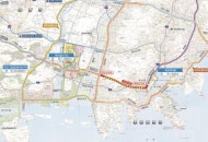
![Day 6 on the Korea Cross Country Cycling Road [KOREA JOONGANG DAILY]](https://imgnews.pstatic.net/image/640/2025/10/21/0000078560_002_20251021120110914.jpg?type=w860)
This final stretch of the river is surprisingly sparsely populated, and it’s worth stocking up at a convenience store before you leave town. There’s practically nothing to eat between here and Busan, and you could get caught short if you’re not well prepared.


Ten kilometers outside Namji is the Changnyeong Hamanbo stamp, which you have been working toward since probably midafternoon on Day 5. The ride from Namji is mostly flat with a few ramps, which sets you up nicely for a final 90-kilometer (56-mile) push to the Nakdong Estuary.
It’s 55 kilometers from Changnyeong Hamanbo to Yangsan Water Culture Park, and it’s not especially fun. Mostly flat with just one short climb in the middle, this section of the trail is essentially an endurance test. There are no stamps to collect, no convenience stores to stop at, no restaurants to eat at, and, for a lot of it, not even any other cyclists to politely nod to.
![The Nakdong River starts to widen on the northern edges of Changwon, South Gyeongsang on Oct. 2. [JIM BULLEY]](https://imgnews.pstatic.net/image/640/2025/10/21/0000078560_005_20251021120111208.jpg?type=w860)

There are bike routes on both banks of the river at this point, and the official route signage tends to push you to what is now the north bank. Kakao Maps prefers the south, which is five kilometers shorter but with that one climb. I followed Kakao, but swapping the climb for an extra five kilometers on flat ground might actually have been preferable.
When you finally reach Yangsan Water Culture Center, you’re just 35 kilometers away from the finish line. Civilization starts to reappear at this stage, beginning with a large park and some food trucks and then slowly building as you get closer to Busan. The food trucks are likely the first chance you’ve had to eat since breakfast, so stop and refuel.

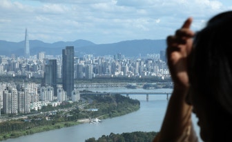
The road into Busan is mainly flat and mostly follows a series of parks into the city. You reach Busan itself with about 15 kilometers left on the clock, and things get a bit unpleasant as the city traffic builds up around you.
While you’re never actually on the road, western Busan — through which the river flows — is a very industrial area, and you find yourself riding the best part of 10 kilometers through a long, narrow park on an embankment between two major roads.

The noise of traffic and taste of fumes, however apt, isn’t an especially warm welcome to Busan, but it isn’t long before the traffic spits you out and you cross your final bridge of the entire ride onto Eulsuk Island at the mouth of the Nakdong River.
The signage here makes it easy to find the final certification center, but it’s actually quite tricky to locate the best spot for a finish line photo. A large rock marks the start of the cross-country route for cyclists beginning in Busan, but if you look on the other side, under the low-hanging branches of a tree, there’s a marker for the finish as well.
![Reaching the end of the Korea Cross-country Cycling Road in the Nakdong River Estuary in Busan on Oct. 2. [JIM BULLEY]](https://imgnews.pstatic.net/image/640/2025/10/21/0000078560_009_20251021120111669.jpg?type=w860)
All cyclists can then go into the certification center and have their achievement certified. If you’re a Korean resident, it means the stamps are verified, and some gold and silver stickers appear on the certification page. Tourists can get that, too, as well as the certificate and medal for a small fee (Korean residents can apply for the medal online and receive it through the post).
With the cross-country route completed, you now have a few options ahead of you in Busan.

Built on a very rocky coast, Busan is a difficult city to navigate by any means of transport, especially by bike. The most attractive place to end your cross-country tour is obviously with a cool pint in hand on the beaches of Gwangan or Haeundae, 30 kilometers on the other side of the city. But getting there is the challenge.
If you’ve arrived in Busan on a rented bike, you presumably have instructions on how to return it there and can then take the subway or a taxi across town. If you’re on your own bike, options are more limited.
If your goal is to stay at the beach and you’ve arrived on the weekend, the subway is an option. If it’s a weekday, you will have to ride across town.
If you want to stay closer to the finish line, the Sasang Station area is an easy 10-kilometer ride away and has plenty of accommodation options and subway links across town (including to the beach). Five kilometers further on takes you to Seomyeon Station, a bigger hub.
If you’re planning to fly out of Busan, you can cycle 10 kilometers up the other side of the Nakdong River to Gimhae International Airport, where you can lock up your bike by the subway station until you need it again.
Alternatively, if you don’t have the energy to explore Busan, the Seobusan area to the west of Eulsuk Island and the Dadaepo area to the south offer plenty of nice accommodation options within 10 kilometers of your location. Both would also set you up nicely if the airport were your final destination.